Hi Friends ..............
Here I am writing a post related to conversion of KML file to Auto Cad dwg file........without any Software.........i.e Plex Earth or Global Mapper......OK Friends just follow these steps...

Now you will get the line in Auto CAD what you have drawn in google Earth and saved it as KML....
Ok Friends............I Hope you got it. still you have doubts just comment below.....
Wish you A Happy New Year.....................Friends........................
Here I am writing a post related to conversion of KML file to Auto Cad dwg file........without any Software.........i.e Plex Earth or Global Mapper......OK Friends just follow these steps...
- Step 1: Save the Path in Google Earth as KML file........
- Step 2: After savng the path as KML just change file type to xml
- Step:3 Next open that xml file in Excel you just Open it as XML table you will get the output like this........
Click OK..........
Please Note That These Lat,Long Details in All Rows represent same. so just copy one row details and do delimited which are separated by comma arrange it in format shown below.
Delimiting the values extracted from XML
- Step 4: Convert these Lat, Long to X, Y coordinates for this download the excel sheet which I kept in below link.
Coordinate Converter NEW
- Step 5: In this Excel workbook just paste these lat, long details in J, K columns of Batch Convert Lat, long to UTM Sheet of this workbook you will get UTM output in AE and AF columns.
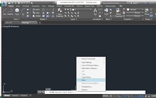
- Step 6:Concatenate these X, Y coordinates and paste it in Auto CAD .....just by typing PL in command bar.........
Concatenating the UTM coordinates.

Pasting Coordinates in AutoCAD
Now you will get the line in Auto CAD what you have drawn in google Earth and saved it as KML....
Ok Friends............I Hope you got it. still you have doubts just comment below.....
Wish you A Happy New Year.....................Friends........................


