Saturday 30 December 2017

Simple technique to Convert the of KML file to DWG ...........

Hi Friends ..............

Here I am writing a post related to conversion of KML file to Auto Cad dwg file........without any Software.........i.e Plex Earth or Global Mapper......OK Friends just follow these steps...
  • Step 1: Save the Path in Google Earth as KML file........
  • Step 2: After savng the path as KML just change file type to xml


  • Step:3 Next open that xml file in Excel you just Open it as XML table you will  get the output like this........
Click OK..........


          Please Note That These Lat,Long Details in All Rows represent same. so just copy one row                details and do delimited which are separated by comma arrange it in format shown below.

Delimiting the values extracted from XML
  • Step 4: Convert these Lat, Long to X, Y coordinates  for this download the excel sheet which I kept in below link.

Coordinate Converter NEW

  • Step 5: In this Excel workbook just paste these lat, long details in J, K columns of Batch Convert Lat, long to UTM Sheet of this workbook  you will get UTM output  in AE and AF columns.
                                                      Conversion of Lat, Long to UTM
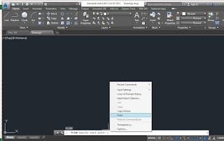
  • Step 6:Concatenate these X, Y coordinates and paste it in Auto CAD .....just by typing PL in command bar.........

Concatenating the UTM coordinates.

                               
Pasting Coordinates in AutoCAD


Now you will get the line in Auto CAD what you have drawn in google Earth and saved it as KML....

Ok Friends............I Hope you got it. still you have doubts just comment below.....

                           Wish you A Happy New Year.....................Friends........................


Thursday 9 November 2017

Conversion of UTM (X,Y) Coordinates to Lat -Long and Lat-Long to UTM (X,Y)


Hi Friends Today I am going to explain the procedure for conversion of UTM (X,Y) coordinates  to Lat-Long (Degree -Minute-Seconds).vice versa........


First Step Download the Excel Sheet from the link mentioned below.

Coordinate Converter


You will see four different sheets in that excel workbook. Choose the Respective Sheet as per your requirement.


(1) UTM(X,Y ) to Lat-Long  Conversion............

Choose Batch Convert UTM to Lat-Long sheet.

Fill the first D, E, F and G columns


You will get the output in Green Highlighted Cells........

(2) Conversion from Lat-Long to X,Y(Northing or Easting)...............

Fill D, E,F,G,H and I Columns You Will get Out put in Green Highlighted cells

That it Simple Friend go through it Enjoy ...............


Sunday 5 November 2017

Arunachal Pradesh Visit .......Its Different.....Its Nice.....Its Difficult.....

In 2017 February I got a chance to visit Arunachal Pradesh State for discussion and finalization of 
the alignment of 3 roads. First one is  Yingikiong to Bishing, Seond is from Zido to Singha and Final one is Khanu to Konsa Road it is near to Nagaland...........


To reach Arunachal Pradesh Firstly I traveled by 3 modes mainly........
1. Air way.......New Delhi to Dibrugarh (Assam).
2. Waterway...... Dibrugarh to Pasighat (Arunachal Pradesh) Ferry Ride.
3.Roadway.........Pasighat to Yingikiong,up to Palling


Inner Line Permit(ILP) is required to visit Arunachal Pradesh.....we got it in Dibrugarh....

To get online ILP click on the link below.

ILP Site


All these ways given nice experiences up to Pasighat trip was awesome, after that feeling got diverted.

Lets have a look of my journey through Pics......


Pilot announced that hello passengers you cane see the awesome view of  Mount Everest............So I captured it ........... 


Google Earth View not from Computer............it is from Flight..........


Ferry Ride From Dibrugarh.................almost 2 to 3 hours taken to reach

Bogi beel Bridge under Construction.........


Roadway Started from Pasighat to Yingikiong......... Rain Started yaar....... 


Project Site Some where like this..........

you cant be sure that there is road untill you move on 

some where we got strucked........

                                                             Awesome view of  Dense hill.

Land slide issues........2 hours no movement on the road.......


Pure water facilities are awesome...............Like this........